THORNSTON, BOSHERSTON
Disgrifiadau
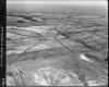
Black and white oblique aerial photograph taken by the RAF in 1952, centred on Thornston, Bosherston and the Castlemartin Range.
Ffynhonnell allanol:

More items with these tags
Related items


Cysylltwch â Ni
I wneud cais i dynnu i lawr neu riportio cynnwys hiliol, sarhaus neu niweidiol mewn unrhyw ffordd arall.

Sylwadau (2)
Submitted by Adrian T A James on Maw, 23/10/2012 - 23:43
Seemingly a sparse photograph with little to see, but.....
-In the distance can be seem the buildings of Newton Camp, with the water tower on the high ground to the south. The water for the camp was pumped from the Lily Ponds at Bosherston, but was not drinkable.
In the foreground is the very clear shape of the eastern end of the a moving target system, to the SW of Carew Farm. The siding for the storage of trolleys is clearly visible. The trench for the target rail runs towards the camera. On the right of the frame is the mound and bank protecting another moving target rail. these were built in the summer of 1943.
Thornston itself is possibly just on the extreme left of the frame. The buildings visible there are, however, those of Buckspool Farm. In the far distance, above Buckspool the farm buildings of Trevallen can be made out, with the road wending its way to Broadhaven hidden amongst the area of trees.
The road running from Buckspool, past Midland across the frame to Crickmail (off frame right).
Submitted by Comisiwn Brenh… on Mer, 24/10/2012 - 10:23
Thanks for bringing the photograph to life - it takes local knowledge to fill in the details & help us appreciate the history of a locality, thanks for taking the time to do this, RCAHMW
You must be logged in to leave a comment