Middleton Hall Excavation - Trench II (5) 2011
Disgrifiadau
On the final day of the excavation, the trench was given a good clean by the volunteers so that elevated photographs could be taken. It was during the final stages of excavation that a further gravel path was located adjoining the path running north-south in the centre of the trench. The angle of this path however ran on an east-west alignment and it is likely that this ran close to the edge of the large water feature located to the west of this trench, however further excavation is needed to provide further evidence for this hypothesis (Austin & Dollery 2011).
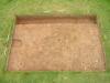
In this elevated photograph looking south, you may appreciate how difficult the archaeology is to see, however if you look closer you can notice some changes. To the east you can see the fully excavated feature that has been associated with bedding and planting. As your eyes follow to the right you will notice that the light brown soil becomes darker drown and the concentration of stone becomes more apparent. This is the remains of the gravel path. Then at the western extent of the trench the concentration of larger stones becomes apparent demarcating a boundary between the gravel path running north-south in the centre of the trench. What is not clear on the photograph is the adjoining gravel path which runs east-west. It is located in the north east corner of the trench (bottom right of the photograph). You might be able to make out that there is a slight colour change which is the same as the soil colour in the centre of the trench and that there is a continuation of small stones, again similar to those located in the centre.
The excavation of Trench II provided much information on the extent of survival of the garden associated with Middleton Hall. A clear archaeology was identified that is well preserved and also has the potential to date specific sealed contexts. Secondly, and perhaps more importantly, the archaeology that was discovered certainly gives good indication of a 17th century garden (Austin & Dollery 2011). It can now be said for certain that the garden contained gravel paths that would have been used as the main thoroughfares through the formal garden and that there are deliberate features that reflect some form of formal planting on the site. Also a clear narrative can also been deduced from looking at the phasing of the archaeology as there are signs of not only possible repair to some of the garden features such as the gravel path but also clear evidence of later use of the landscape in the form of the stake holes that reflect deliberate attempts to establish land divisions that almost certainly date to the farm that was erected in the 1930’s (Austin & Dollery 2011).
Austin, D. & Dollery, J. The Excavation. In Austin, D [Ed] 2011 Paradise Lost In Search of a Garden before the Garden: Middleton Hall. Report of project conducted in 2011. Heritage Lottery Fund

More items with these tags
Mae'r eitem hon hefyd yn ymddangos yn


Cysylltwch â Ni
I wneud cais i dynnu i lawr neu riportio cynnwys hiliol, sarhaus neu niweidiol mewn unrhyw ffordd arall.

You must be logged in to leave a comment