Middleton Hall Excavation - Trench II (3) 2011
Disgrifiadau
Once the garden feature in the east of the trench has been excavated our attention them moved to the archaeological deposit located in the centre of the trench which consisted of orangey brown soil with a high concentration of stone and gravel (Austin & Dollery 2011). After cleaning the feature by trowling it became apparent that this feature was linear and had a definitive edge both to the east and west, however to the north of the trench this distinctive edge seemed to disappear (ibid). With the composition of the context being comprised of a high degree of compacted stones and gravel it was clear that this feature was probably a gravel path and equated to the features that had been picked up on the radar survey of the site (Booth & Murray 2011). It was also apparent from further investigation of the north west of the trench that this feature turned 90 degrees and carried on heading to the west (Austin & Dollery 2011). It also became clear that we had reached an intersection of two paths, one running north south, the other running east west, on an alignment that seemed to continue along the edge of the large rectangular water feature (ibid).
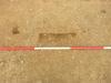
While cleaning the gravel path running north south in the centre of the trench further archaeological features where also discovered. There were three circular features that where spaced at regular intervals again, heading north to south and where comprised of dark brown soil. There was also a further feature that was irregularly shaped located in the south half way between two of the circular features (see image). These features where half sectioned and found to be very shallow, penetrating an inch or so into the gravel path. The fact that these features where cut into the gravel path confirmed that they superseded the thoroughfare and therefore much have been a later event. With the fact that these features came later than the gravel path and were spaced at regular intervals it was highly likely that these where in fact stake holes created by wooden stakes to create a fence (ibid). Due to the shallowness of these features it is likely that these features where likely to be modern, perhaps relating to the 1930’s farmhouse located 100m to the south.
This photograph shows two of the features, the circular feature to the left is similar to the other two features that where located to the north and south of this feature. The feature to the right of this stake hole, although irregularly shaped is again probably a stake hole that went awry, its shape reflecting possibly more than one attempt to erect a wooden post.
Austin, D. & Dollery, J. The Excavation. In Austin, D [Ed] 2011 Paradise Lost In Search of a Garden before the Garden: Middleton Hall. Report of project conducted in 2011. Heritage Lottery Fund
Booth, A & Murry, T. Geophysical Survey 1. In Austin, D [Ed] 2011 Paradise Lost In Search of a Garden before the Garden: Middleton Hall. Report of project conducted in 2011. Heritage Lottery Fund.

More items with these tags
Mae'r eitem hon hefyd yn ymddangos yn


Cysylltwch â Ni
I wneud cais i dynnu i lawr neu riportio cynnwys hiliol, sarhaus neu niweidiol mewn unrhyw ffordd arall.

You must be logged in to leave a comment