Middleton Hall Excavation - Trench II (1) 2011
Disgrifiadau
The purpose of Trench 2 was to identify whether any archaeological features associated with a formal garden survived. From the earthwork survey that was carried out in 1999 by Edward Baker, it was apparent that the earthworks to the west of the house platform where almost certainly engineered. The size, shape and position of these features suggested that they where ornamental in nature and where most likely to be garden terraces for a formally arranged garden (Baker 1999). The identification and interpretation of the earthworks within Waun Las gave some indication as to what type of garden may have been implemented upon the site in the 17th century. During this period the common garden style of garden; especially those associated with patrons who where wealthy; would have been baroque in style, mimicking, albeit on a much smaller scale, the renaissance gardens of Versailles and Hampton Court. This was an exciting prospect as many baroque style gardens within Wales have not survived. This is primarily due to the fact that gardens are one of the most turbulent and interchanging spaces and are dependent on both maintenance and of the tastes and fashions of the period, many such gardens changing type and style over many successive periods, for example like the gardens of Aberglasney. Although the garden at Middleton Hall had long since gone, its archaeological remains could possibly still be detected, depending on the extent of survival, which if the area had been ploughed or cultivated since the demolition of the hall, then finding these features would be extremely difficult. To add further weight to this interpretation of a formally arranged garden was the identification of a possible pond or ornamental water feature located to the west of the terraces, in the present form of a large rectangular shaped depression.
Again similarly to Trench 1, Trench 2 was placed over some anomalies that were detected during Dr Adam Booth’s radar survey of the site. The anomalies that where picked up within this area where a series of linear features that ran north to south across the extent of the earthwork terraces (Booth & Murray 2011). The preliminary interpretation of these features was that they where possibly the remains of gravel paths or bedded track ways that would have provided access though a formally arranged garden. Trench 2 was the largest of the trenches to be excavated during the 2011 season, measuring 6m by 4m. The trench was placed over a section of these anomalies and located roughly 2 meters away from the edge of the large rectangular water feature situated to the west of the terraces.
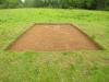
This photograph, looking west towards the great glass house, was taken at the end of the first day of excavation once the turf had been removed. In comparison to Trench 1, this area of the excavation was of a completely different character. In Trench 1, once the turf and topsoil had been removed, archaeology was immediately discovered in the form of rubble deposits. In this area however, the narrative was completely different, primarily because the turf and topsoil was deeper in this area.
Baker, E. 1999 Cultural Landscape Management: Work placement assignment, National Botanic Garden. University of Wales, Lampeter, unpublished.
Booth, A & Murry, T. Geophysical Survey 1. In Austin, D [Ed] 2011 Paradise Lost In Search of a Garden before the Garden: Middleton Hall. Report of project conducted in 2011. Heritage Lottery Fund.

More items with these tags
Mae'r eitem hon hefyd yn ymddangos yn


Cysylltwch â Ni
I wneud cais i dynnu i lawr neu riportio cynnwys hiliol, sarhaus neu niweidiol mewn unrhyw ffordd arall.

You must be logged in to leave a comment