Middleton Hall Excavation - Trench I (4) 2011
Disgrifiadau
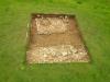
This is the final photograph of the excavation and as you can see, an amazing discovery was made, literally on the last day of the excavation. From the previous photograph you could see that a red sandy soil covered the extent of the western rubble deposit (top of picture). Once this layer had been recorded a few volunteers began to excavate it to reveal what lay underneath. We were positive from the composition of this deposit that this was the very bottom of the demolition material associated with the destruction of the hall, and so we were confident that we would uncover an occupational surface (a surface that would have been contemporary with the hall) of some kind beneath it (Austin & Dollery 2011). However we were not expecting what was soon to be discovered. As the volunteers continued to excavate the red soil, large rounded cobble stones began to appear. Before we knew what was happening a large area of cobbles had been uncovered (top centre of photograph). We had discovered the original floor surface of the hall.
The mystery of the anomaly that was detected with Dr Booth’s survey was finally laid to rest as the cobbles roughly covered, certainly in width the size of the anomaly that was picked up (Booth & Murray 2011). However the length of 15m gave some indication that there were more cobbles or rather more solid occupation surfaces to be picked up further to the north; however that hypothesis would have to wait until further excavation on the site was conducted. There was one intriguing twist to this theory, the depth. The original depth of the anomaly that was highlighted by the radar survey was at 1m below the surface whereas the cobbled surface we discovered was much higher than that resting about 30cm from the surface.
The discovery of the cobbles and their relationship to the large negative feature also gave some evidence to suggest what this feature was. Due to the linear nature of the feature and also its large width, far to excessive for footings for a pipe it soon became clear that we were in fact looking at a robber trench, that had been excavated after the demolition of the hall to remove the walls and possibly foundations to be reused elsewhere. The dating material concluded that this was probably excavated during the early 19th century and was contemporary with Sir William Paxton’s occupation of the estate. This gave us a further chapter in the narrative of the hall that continued after its demolition, that the site was used as source for building material, in particular stone. If effectively became a quarry.
Austin, D. & Dollery, J. The Excavation. In Austin, D [Ed] 2011 Paradise Lost In Search of a Garden before the Garden: Middleton Hall. Report of project conducted in 2011. Heritage Lottery Fund
Booth, A & Murry, T. Geophysical Survey 1. In Austin, D [Ed] 2011 Paradise Lost In Search of a Garden before the Garden: Middleton Hall. Report of project conducted in 2011. Heritage Lottery Fund.

More items with these tags
Mae'r eitem hon hefyd yn ymddangos yn


Cysylltwch â Ni
I wneud cais i dynnu i lawr neu riportio cynnwys hiliol, sarhaus neu niweidiol mewn unrhyw ffordd arall.

You must be logged in to leave a comment