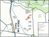
Location of the Site Grid 2011
Disgrifiadau
Location of the Site Grid 2011
In 2011 a programme of archaeological investigation of Waun Las was conducted by volunteers from the National Botanic Garden supervised by archaeologists from the University of Wales, Trinity Saint David. The excavation was for 10 days in which three areas key areas would be explored (Austin & Dollery 2011).
Trench 1 was located to the north of Waun Las farm, upon a large flat terrace that had been interpreted as the house platform, or was at least the best location for a large hall to be situated. The main purpose of this trench was to find any archaeological evidence of the original Middleton Hall providing solid evidence that the original hall was indeed located within the vicinity of Waun Las and to assess in what condition it survived as agricultural activity of the nearby farm such as ploughing could have had a severe impact on the survival of the archaeology (Austin & Dollery 2011). In the weeks before the excavation began, Dr Adam Booth from Swansea University’s physical geography department did a ground penetrating radar (GPR) survey of the field to identify if any remains of the hall could be discovered remotely and to give some indication of the best locations to start excavating. The results of the survey where fascinating and features such as the large rectangular water feature showed up very clearly. On the hall platform an interesting area was also discovered. An area ranging 15 meters in length and 5 meters in width was picked up at a rough depth of 1 meter. Due to the size, shape and depth of the feature it was first though that this could have been the remains of a cellar and therefore the best location to start excavating as archaeology was more likely to have survived within this feature as it would have not been affected too much by later disturbances such as ploughing (Booth & Murry 2011, Austin & Dollery 2011). To investigate this feature a trench of 5m x 5m was marked out roughly in the centre of this large rectangular feature.
Trench 2 on the other hand was positioned at the bottom of the large earthwork terraces to identify if there were any remains of garden features associated with the hall. It was anticipated that if garden features survived (depending if the field had been ploughed in the past and to what extent this had damaged the archaeology) then they would probably be formally arranged in the baroque style, similar to those garden styles of Hampton Court and St James Park, London (Austin & Dollery 2011). Again Dr Adam Booth’s GPR survey helped locate an intersection of what appeared to be large linear features, possibly the remains of gravel paths (Booth & Murry 2011). To investigate these features a trench of 6m x 4m was marked out. The reason for the larger trench was to ensure that not only the possible gravel paths would be located but possibly other archaeology garden features such as planting beds would also be discovered (Austin & Dollery 2011).
Trench 3 was the last trench to be opened. It was decided during the excavation of Trench 1 and Trench 2 that a further trench should be opened to explore the large rectangular depression that had been interpreted as a large ornamental water feature. The main priority of this trench was to assess what type of deposits composed of the fill of this feature (Austin & Dollery 2011). One theory was that during the destruction and demolition of Middleton Hall during the late 18th century that some of the rubble might have been dumped into this feature to aid in the picturesque landscaping of the area and eradicating all trace of the previous Middleton occupation of the site. Therefore it was logical to deduce that a significant proportion of material culture could have potentially been buried in this feature therefore making it a prime candidate to warrant further investigation. A small 5m x 5m trench was opened up in the south western corner of the feature. The reason for positioning the trench in this area was also to investigate the banks of the feature so it could also be understood how the water feature was created in the first place and also possibly to gain some dating evidence of when the feature was constructed (Austin & Dollery 2011).
Austin, D. & Dollery, J. The Excavation. In Austin, D [Ed] 2011 Paradise Lost In Search of a Garden before the Garden: Middleton Hall. Report of project conducted in 2011. Heritage Lottery Fund.
Booth, A & Murry, T. Geophysical Survey 1. In Austin, D [Ed] 2011 Paradise Lost In Search of a Garden before the Garden: Middleton Hall. Report of project conducted in 2011. Heritage Lottery Fund.

More items with these tags
Mae'r eitem hon hefyd yn ymddangos yn


Cysylltwch â Ni
I wneud cais i dynnu i lawr neu riportio cynnwys hiliol, sarhaus neu niweidiol mewn unrhyw ffordd arall.

You must be logged in to leave a comment