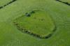
CAER DIN
The People's Collection is using (with some modifications) the licence developed by the Creative Archive Licence Group, including the BBC, the British Film Institute (BFI). Channel 4, the Open University, Teachers TV, Museum and Library Archive (MLA) and ITN Source.
Read more about the All Rights Reserved.
Disgrifiadau
RCAHMW colour oblique aerial photograph of Caer Din taken on 02/06/2004 by Toby Driver
Ffynhonnell allanol:
Uwchlwytho gan
Dyddiad Ymuno:
24/07/2009
Owner:
RCAHMW Colour Oblique Digital Aerial Photographs
Gwybodaeth drwydded
Reproduced by permission of
Royal Commission on the Ancient and Historical Monuments of Wales
Copyright Details:
2004
Publisher Ref:
35487
Eitem wedi’i llwytho:
18/11/2009
Date originally created:
2/6/2004
Gwelediadau:
780
Ffefrynnau:
0
More items with these tags
Related items
-
SIMON'S CASTLE; SYMON'S CASTLEMath EitemauUwchlwytho gan Comisiwn Brenhinol Henebion Cymru -
CHURCHSTOKEMath EitemauUwchlwytho gan Comisiwn Brenhinol Henebion Cymru -
WERDDU, FARMSTEAD WITH EARTHWORKS IN SURROUNDING FIELDSMath EitemauUwchlwytho gan Comisiwn Brenhinol Henebion Cymru -
SITE SOUTH OF BAGBURY;BAGBURY ENCLOSURE & POSSIBLE FIELD SYSTEMMath EitemauUwchlwytho gan Comisiwn Brenhinol Henebion Cymru -
UPPER ALDRESS MOATMath EitemauUwchlwytho gan Comisiwn Brenhinol Henebion Cymru -
ROUNDTON HILLFORTMath EitemauUwchlwytho gan Comisiwn Brenhinol Henebion Cymru -
TODLETH HILL, ENCLOSUREMath EitemauUwchlwytho gan Comisiwn Brenhinol Henebion Cymru -
PENTRE WOOD, DEFENDED ENCLOSURE; PENTRE CAMPMath EitemauUwchlwytho gan Comisiwn Brenhinol Henebion Cymru -
COURTHOUSE BRIDGE, CROPMARK ENCLOSURE E OF;COLOMENDY ENCLOSUREMath EitemauUwchlwytho gan Comisiwn Brenhinol Henebion Cymru -
CHURCHSTOKEMath EitemauUwchlwytho gan Comisiwn Brenhinol Henebion Cymru
Cysylltwch â Ni
I wneud cais i dynnu i lawr neu riportio cynnwys hiliol, sarhaus neu niweidiol mewn unrhyw ffordd arall.
You must be logged in to leave a comment