Map of Hearson Camp Sardis Pembrokeshire
Gellir lawrlwytho cynnwys at ddibenion anfasnachol, megis at ddefnydd personol neu mewn adnoddau addysgol.
At ddibenion masnachol cysylltwch â deiliad yr hawlfraint yn uniongyrchol.
Read more about the Trwydded Archif Greadigol.
Disgrifiadau
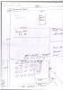
A brief hand drawn map of Hearson Camp Pembrokeshire showing some aspects of the camp including the exercise area, officers amenities and the underground trenches.
Uwchlwytho gan
Dyddiad Ymuno:
03/03/2021
Eitem wedi’i llwytho:
29/3/2021
Gwelediadau:
304
Ffefrynnau:
0
More items with these tags
Related items
-
Welsh Fortresses Through Time — 186 Sites Across Three Thousand Years of Fortress-Building in Wales
Math EitemauUwchlwytho gan Graham T Emmanuel -
A Timeline of Conflict in Wales 616–1421 AD — Complete Historical Narrative Companion
Math EitemauUwchlwytho gan Graham T Emmanuel -
The Mills of Wales — Wind, Water and Tidal Heritage: A Complete Survey of 84 Historic Mill Sites
Math EitemauUwchlwytho gan Graham T Emmanuel -
Oes y Sant — The Age of the Saints: An Interactive Map and Companion Guide to the Sacred Landscape of Wales, c. AD 450 to 600
Math EitemauUwchlwytho gan Graham T Emmanuel -
War Memorial Ledger for West Walesl-QR‑Coded
Math EitemauUwchlwytho gan Graham T Emmanuel -
Merched Beca — The Rebecca Riots of West Wales 1839–1844 — An Interactive Heritage Map and Digital Archive
Math EitemauUwchlwytho gan Graham T Emmanuel -
Turnpike Roads of South-West Wales · Milestones, Toll Gates and Lost Infrastructure 1700–1844
Math EitemauUwchlwytho gan Graham T Emmanuel -
Anfoneb oddi wrth J W Thomas a'i Feibion, Llandeilo, 13 Awst 1965Math EitemauUwchlwytho gan Hengwrt -
Bosherston 1841 Census Charts
Math EitemauUwchlwytho gan Chris Ball -
Pen-y-Holt stack
Math EitemauUwchlwytho gan Chris Ball
Cysylltwch â Ni
I wneud cais i dynnu i lawr neu riportio cynnwys hiliol, sarhaus neu niweidiol mewn unrhyw ffordd arall.
You must be logged in to leave a comment