Caerwent Plan
Caerwent Plan
Disgrifiadau
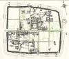
1948 Plan of Caerwent showing Caerwent Exploration Fund excavation sites annotated with Roman numerals. The house and features to the north of the Via Principalis (horizontal centre road) have a ‘N’ suffix and those to the south an ‘S’. After Frank King's 1911 plan of Caerwent
Ffynhonnell allanol:

More items with these tags
Mae'r eitem hon hefyd yn ymddangos yn

Cysylltwch â Ni
I wneud cais i dynnu i lawr neu riportio cynnwys hiliol, sarhaus neu niweidiol mewn unrhyw ffordd arall.

You must be logged in to leave a comment