Penarth, Vale of Glamorgan: Map/Figure
Penarth, Vale of Glamorgan: Map/Figure
Disgrifiadau
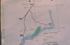
Llun: 1
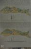
Lavernock Geology cliff and beach platform shale bands and clay mud
Lavernock Point Map. Position of Nature Reserve. December 1982
Dyddiad: December 1982
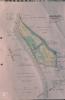
Llun: 2
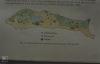
Lavernock Geology cliff and beach platform shale bands and clay mud
Lavernock Point map. Scrub - spread in reserve. 1980
Dyddiad: 1980
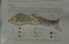
Llun: 3
Sully Island Maps
Sully Island map of vegetation. (Peter Ferns)
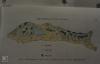
Llun: 4
Sully Island Maps
Sully Island map of Rabbits. (Peter Ferns)
Llun: 5
Sully Island Maps
Sully Island map of mice and voles (Peter Ferns)
Llun: 6
Sully Island Maps
Sully Island map of uncommon mammals (Peter Ferns)
Ffynhonnell allanol:

More items with these tags
Related items


Cysylltwch â Ni
I wneud cais i dynnu i lawr neu riportio cynnwys hiliol, sarhaus neu niweidiol mewn unrhyw ffordd arall.

You must be logged in to leave a comment