Penarth, Vale of Glamorgan: Geology & Landscape
Disgrifiadau
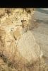
Llun: 1
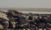
St Mary's Well Bay
White Lias slabs. Cliff West of Penarth, March 1973
Dyddiad: March 1973
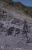
Llun: 2
Views from Penarth Head and over Cardiff Bay
Heap of crumbled shale east of Lavernock. Lower Penarth
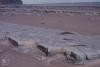
Llun: 3
Lavernock Geology cliff and beach platform shale bands and clay mud
Lias Beach, shale under sandstone surface. West of Lavernock Point. August 1978
Dyddiad: August 1978
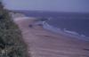
Llun: 4
Lavernock Geology cliff and beach platform shale bands and clay mud
Bristol Channel sands below the Jurassic Cliffs of Lavernock Reserve. Lavernock Point, horizon, bedding, storm beach.
Llun: 5
St. Mary's Well Bay. Lias cliffs in East.
Outcrop on beach platform. St Mary's Well bay.

More items with these tags
Related items


Cysylltwch â Ni
I wneud cais i dynnu i lawr neu riportio cynnwys hiliol, sarhaus neu niweidiol mewn unrhyw ffordd arall.

You must be logged in to leave a comment