Penarth, Vale of Glamorgan: Landscape


Disgrifiadau
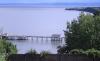
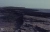
Llun: 1
Penarth Front
Penarth Pier and Lavernock Point from Penarth Head 2000 (duplicate)
Dyddiad: 2000
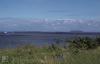
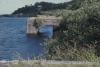
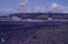
Llun: 2
Penarth Front
Ships and Holms. Lower Penarth Cliffs, 16/08/78
Dyddiad: 16/08/1978
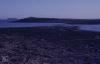
Llun: 3
View up Ely from Penarth old inner dock to Taff Gorge. Old road down. 04/08/00
Dyddiad: 04/08/2000
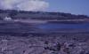
Llun: 4
Penarth. Ely. New Dock Road. Old wharf and warehouse, 04/08/00
Dyddiad: 04/08/2000
Llun: 5
Penarth Docks
Loading bays. Penarth middle dock. West side, 1979
Dyddiad: 1979
Llun: 6
Outer Penarth Dock at low water looking seaward, September 1974
Dyddiad: September 1974
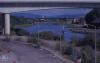
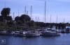
Llun: 7
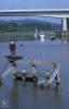
Cardiff Bay barrage from above Penarth Marina. Curves in leaving Alexandra Dock lock open to sea. August 2000
Dyddiad: August 2000
Llun: 8
Cardiff Bay from Penarth old red docks office centre. Craig Llanishen in distance from road below High View Road, August 2000
Dyddiad: August 2000
Llun: 9
Ely mouth and Cardiff Bay 2000
Moored boats, East bank of River Ely against Ferry Road, 04/08/00
Dyddiad: 04/08/2000
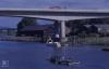
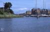
Llun: 10
Ely mouth and Cardiff Bay 2000
Yachts to seaward of Penarth Marina from boat, 24/02/01
Dyddiad: 24/02/2001
Llun: 11
Ely mouth and Cardiff Bay 2000
Ely mouth, Mayweed. Victoria Wharf opposite Cogan Spur crossing, 14/08/01
Dyddiad: 14/08/2001
Llun: 12
Penarth Dock (inner and middle doacks West of Taff-Ely basin)
Penarth middle dock view from old loading bay to open way to outer dock basin. 26/05/90
Dyddiad: 26/05/1990
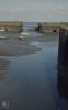
Llun: 13
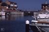
Penarth Dock (outer) with and without ice
High tide in outer dock, Penarth, May 1984
Dyddiad: May 1984
Llun: 14
Penarth Dock (outer) with and without ice
Inside of Penarth marina sea lock. Closed at low water. Clinically clean, no plant in sight. 26/05/90
Dyddiad: 26/05/1990
Llun: 15
Penarth Dock (outer) with and without ice
Outside Penarth sea lock, low water. 26/05/90
Dyddiad: 26/05/1990
Llun: 16
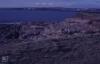
St Marywell Bay. Boxing Day 1980
Dyddiad: 26/12/1980
Llun: 17
Sully Island Maps
Sully Hospital from South West corner of Sully Island. November 1986
Dyddiad: November 1986
Llun: 18
Sully Island Maps
Sully Island causeway from summit of island to south east. November 1986
Dyddiad: November 1986
Llun: 19
Sully Island Maps
North east scrub Sully Island. View to Lavernock Point. November 1986
Dyddiad: November 1986
Llun: 20
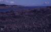
Sully Island Causeway
Sully Island Causeway and West scrub. May 1967
Dyddiad: May 1967
Llun: 21
Sully Island Causeway
Causeway and Swanbridge from west side of Sully Island. 1986
Dyddiad: 1986
Llun: 22
Sully Island Causeway
South West Sully Island. Barry and Sully Hospital. 15th November 1986
Dyddiad: 15/11/1986
Llun: 23
Sully Island North beach. Wreck. Horned Poppy
Tide meets over Sully Island Causeway. November 1986
Dyddiad: November 1986
Llun: 24
Dinosaur footprints Sully, Bendricks (Barry)
Swanbridge Farm from causeway to Sully Island. 1986
Dyddiad: 1986

More items with these tags
Mae'r eitem hon hefyd yn ymddangos yn

Cysylltwch â Ni
I wneud cais i dynnu i lawr neu riportio cynnwys hiliol, sarhaus neu niweidiol mewn unrhyw ffordd arall.

You must be logged in to leave a comment