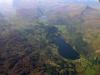
Llyn Gwynant and Llyn Dinas beyond
Llyn Gwynant and Llyn Dinas beyond
Disgrifiadau
Aerial view of Llyn Gwynant in the foreground linked by the Nant Gwynant Pass to the smaller Llyn Dinas. Forming the right-hand side of Llyn Dinas is Yr Aran mountain with Snowdon to its right near the top of the image. If you look to the feet of these two mountains, you can make out the meandering former miners path to a now disused quarry. The path is known as the Watkin path and is credited by many to be the hardest pathup to Snowdon's sumit as it starts almost at sea level, rising up to Snowdon's 3,560feet peak. Taken 12 September 2005.

More items with these tags
Mae'r eitem hon hefyd yn ymddangos yn

Cysylltwch â Ni
I wneud cais i dynnu i lawr neu riportio cynnwys hiliol, sarhaus neu niweidiol mewn unrhyw ffordd arall.

You must be logged in to leave a comment