Prickeston Farm Map 3 House extract
Prickeston Farm Map 3 House extract
Disgrifiadau
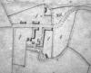
An estate map of Prickeston - given to the tenant. This map was produce in the early nineteenth century, possibly late eighteenth century. The extract shows the arrangements of the farm buildings at this time. Apologies for no scale. This info to follow. North is approximately to the top of the plan.
Compare to the current "satellite" view of the area.

More items with these tags
Mae'r eitem hon hefyd yn ymddangos yn

Cysylltwch â Ni
I wneud cais i dynnu i lawr neu riportio cynnwys hiliol, sarhaus neu niweidiol mewn unrhyw ffordd arall.

You must be logged in to leave a comment