Aerial view of Llaneithyr Farm, Ysbytty Cynfyn, Ceredigion, 2026
Disgrifiadau
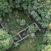
Aerial photograph showing the farm buildings and surrounding landscape at Llaneithyr, near Devil's Bridge, in the parish of Ysbytty Cynfyn, Ceredigion. Llaneithyr was constructed in the 1820s and was occupied from the mid-1840s by tenant farmers who ran it as a sheep farm, noted at the time for having some of the finest sheep walks in the area. The aerial view illustrates the farm's setting within the landscape of the upper Rheidol valley. During and after the First World War, the surrounding land was planted with trees, which contributed to the decline of the farm as an agricultural holding. The photograph was taken in 2026.

More items with these tags
Cysylltwch â Ni
I wneud cais i dynnu i lawr neu riportio cynnwys hiliol, sarhaus neu niweidiol mewn unrhyw ffordd arall.

You must be logged in to leave a comment