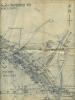
Cowbridge east side street map 1953
Cowbridge east side street map 1953
Disgrifiadau
Cowbridge east side street map 1953
Showing the site of the planned council housing development, for example, dated 22nd May 1953. Cae Stumpie and Borough Close housing was started soon after this date.
[document 26x29]

Cysylltwch â Ni
I wneud cais i dynnu i lawr neu riportio cynnwys hiliol, sarhaus neu niweidiol mewn unrhyw ffordd arall.

You must be logged in to leave a comment