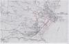
Map of the Tenby and Penally area 1969
Gellir lawrlwytho cynnwys at ddibenion anfasnachol, megis at ddefnydd personol neu mewn adnoddau addysgol.
At ddibenion masnachol cysylltwch â deiliad yr hawlfraint yn uniongyrchol.
Read more about the Trwydded Archif Greadigol.
Disgrifiadau
Copy Ordnance Survey map c.1969 showing the area of the Ritec Valley marshes with hand drawn amendments. 1 item
Uwchlwytho gan
Dyddiad Ymuno:
29/03/2021
Eitem wedi’i llwytho:
29/3/2021
Gwelediadau:
397
Ffefrynnau:
0
Related items
-
Penalun (Casgliadau Llyfrgell Hwlffordd)Eitemau 5 itemsMath CasgliadauUwchlwytho gan Pembrokeshire Archives & Local Studies -
Copy of the Great War Pembrokeshire remembers supplement Llangwm Pembrokeshire 2014Math EitemauUwchlwytho gan Llangwm Local History Society -
Census and Tithe information for Starvation Penally PembrokeshireMath EitemauUwchlwytho gan Penally History Group -
Drawings of Properties Penally PembrokeshireMath EitemauUwchlwytho gan Penally History Group -
Building Floor Plans Penally PembrokeshireMath EitemauUwchlwytho gan Penally History Group -
Aerial photograph of Penally Camp PembrokeshireMath EitemauUwchlwytho gan Penally History Group -
Census Details for Hill Cottage Penally Pembrokeshire 1911Math EitemauUwchlwytho gan Penally History Group -
Census Details for Catherine Davies Penally Pembrokeshire1911Math EitemauUwchlwytho gan Penally History Group -
Census Details for New House Penally Pembrokeshire 1911Math EitemauUwchlwytho gan Penally History Group
Cysylltwch â Ni
I wneud cais i dynnu i lawr neu riportio cynnwys hiliol, sarhaus neu niweidiol mewn unrhyw ffordd arall.
You must be logged in to leave a comment