Ordnance Survey map of Ritec embankment Penally Pembrokeshire
Ordnance Survey map of Ritec embankment Penally Pembrokeshire
Disgrifiadau
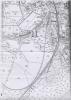
Copy of 2nd edition c.1907 Ordnance Survey Map enlarged and showing railway embankment and high tide point inland of the embankment. 1 item

More items with these tags
Related items


Cysylltwch â Ni
I wneud cais i dynnu i lawr neu riportio cynnwys hiliol, sarhaus neu niweidiol mewn unrhyw ffordd arall.

You must be logged in to leave a comment