Exploring Pembroke Castle Keep


Disgrifiadau
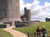
Image 1:
The Keep (left) and Dungeon Tower (centre).
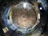
Image 2:
Inside the Keep, looking vertically upwards to the stone domed roof, 75ft above. The walls are 19ft thick at the base, and 50ft in diameter.
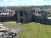
Image 3:
Looking south-eastwards from the top of the Keep, across the Outer Ward to the Great Gatehouse and the town of Pembroke beyond.
Image 4:
Looking eastwards over St Ann's Bastion (right) and upstream along the tidal reaches of the Pembroke River. The bridge carries the A4139 road from north Pembrokeshire to Tenby.
Image 5:
Looking westwards and downstream towards Milford Haven.
Image 6:
This view looking southwards from the top of the Keep shows Monkton Tower (left foreground) and in the distance Monkton Priory, from which the tower gets its name.
Now visit Jeff Thomas's Castles of Wales website, and study the history of Pembroke Castle.

More items with these tags
Mae'r eitem hon hefyd yn ymddangos yn

Cysylltwch â Ni
I wneud cais i dynnu i lawr neu riportio cynnwys hiliol, sarhaus neu niweidiol mewn unrhyw ffordd arall.

You must be logged in to leave a comment