The Cnewr Estate, the Tower, and Crai Reservoir
Disgrifiadau
The Tower and Crai Reservoir
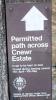
Image 1:
Sign detailing restrictions to footpath across the Cnewr Estate.
Access to the tower can be gained by following a footpath from alongside the A4067. Although the land is in the Brecon Beacons National Park, it runs across the Cnewr Estate. Restrictions are imposed to avoid endangering livestock during the lambing season.
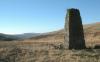
Image 2:
Approaching the tower from the northeast.
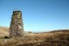
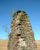
Image 3:
The southwestern aspect of the tower. The tower is about 12 feet high, built of stone and appears to be solid.
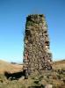
Image 4, 5:
The tower is capped with a flat concrete slab.
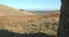
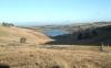
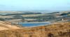
Image 6, 7:
Northeast of the tower is Crai Reservoir, built in the early 1900s.
Crai Reservoir cost £800,000 to construct, covers an area of about 150 acres, and holds over one billion gallons of water. It supplies water to the City of Swansea.
Mystery solved!
Until recently, I was unable to determine the origin and purpose of the stone tower illustrated above. I wondered whether it could simply have been a folly, or whether it had a more practical function. There are no markings or inscriptions on the tower to indicate its purpose. It is identified as Twr (Tower) on modern Ordnance Survey maps, but it was not marked on the 1:10,560-scale Ordnance Survey map of 1891. Now, thanks to Jonathan Jackson, we have a credible explanation for the existence of the tower.
In his e-mail of 24 April 2004, Jonathan wrote:
I passed both the tower and Cnewr itself on my journey to work, for the eighteen years I lived in that beautiful part of the country.
I was led to believe by a number of local folk, that the tower was some sort of marker to do with the tunnel that runs from Crai Reservoir to the old waterworks at Nantyrwydd on the left of the A4067 as you approach the long hill down to Glyntawe. The old Water Board house, by the side of the road, is now a holiday cottage.
On page 210, figure 124, of Stephen Hughes's book The Brecon Forest Tramroad [see publication details below], the author refers to the stone pillar as being "...probably a surveying marker used in the construction of the aqueduct tunnel through the watershed from Crai towards Swansea."
On 13 January 2007, Roger M. Evans, a former water company property manager, wrote to me in support of Jonathan's theory:
My own view for what its worth favours the marker theory as the "Tower" can be clearly seen from both the dam and the old treatment plant; also if it was a vent to the tunnel it would either be better maintained or would be have been replaced nearby by a more modern and secure facility. It would also not have a slab of concrete on the top.
However, a rather different explanation has been suggested by Alan Doyle of the West Midlands. In his e-mail of 24 August 2004, Alan wrote:
I have some more information regarding the Tower at the top of the Bwlch overlooking Crai Reservoir. I have spoken to an old friend who knows the son of the gentleman who was in charge of the waterworks and lived in the house called Nantyrwydd on the right hand side of the road as you approach the top of the Bwlch [from the Swansea direction]. The house was once owned by the water authority. He says "...the tower is a vent for the tunnel that carried water down to the filter bed at Nantyrwydd". The water is now filtered out at the newer site which is behind the Tavern-y-Garreg public house, just down the road. As far as he is aware, the tunnel is still in use today and carries the water to the newer site.
Either of the above explanations would date the tower to the early years of the 20th century, contemporary with the construction of the reservoir, and would explain the absence of the tower from the 1891 Ordnance Survey map.
If you think you can add anything to the discussion, please write to me (John Ball) via my Contact Page
Update – July 2015
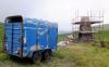
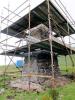
As the two photographs (Image 9, 10) show, restorative work has been taking place on the tower.
In late June and early July 2015, the tower was surrounded by scaffolding and the tower's stonework was secured and repointed. The cap on the top of the tower also appears to have been made safe.
Many thanks to Alan Bowring (Development Officer, Fforest Fawr Geopark) for this update and for allowing me to use his photographs (taken on 26 June 2015). Alan says: I think the work must be being carried out either by Welsh Water/Dwr Cymru or by Cnewr estate on whose land I believe the tower is sited. Either way, it is good to see it happening – I'd watched the stonework crumble these last few years as I passed it from time to time.
Sources
The Archaeology of an Early Railway System -- The Brecon Forest Tramroads by Stephen Hughes, published 1990 by The Royal Commission on Ancient and Historical Monuments in Wales, Aberystwyth. ISBN 1-871184-05-3
The Great Forest of Brecknock: A facet of Brecknockshire history by William Rees, published 1966 by Brecknock Museum, Brecon.
Back to Page 1

More items with these tags
Cysylltwch â Ni
I wneud cais i dynnu i lawr neu riportio cynnwys hiliol, sarhaus neu niweidiol mewn unrhyw ffordd arall.

You must be logged in to leave a comment