Caerfai Bay & Caerbwdi Bay (continued)

Disgrifiadau
Caerfai Bay & Caerbwdi Bay (continued)
We now leave Caerfai Bay, and follow the Pembrokeshire Coast Path eastwards around the headland, eventually reaching Caerbwdi Bay. The photographs below concentrate on the coastal features between the two bays.
Around the Headland
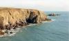
Image 1:
September 1968
The eastern headland of Caerfai Bay is the site of a splendid Iron Age promontary fort, dating from about 3000 BC. The island is known as Penpleidiau.
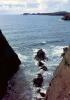
Image 2, 3:
September 1968
Views from the Pembrokeshire Coast Path.From the cliff-top coast path one is rewarded with a series of spectacular views, across the ocean (above left) to distant headlands and the isles to the south of Ramsey Island; and (above right and below) to inviting coves at the base of the cliffs, accessible only at low tide or by boat.
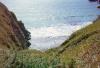
Image 4:
View from Pembrokeshire Coast Path.
September 1968
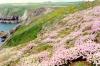
Image 5:**
April 1990
A colourful springtime display of wild flowers on the cliff-tops of the headland between Caerfai and Caerbwdi bays. Note the flat Pembrokeshire landscape in the distance.

More items with these tags
Cysylltwch â Ni
I wneud cais i dynnu i lawr neu riportio cynnwys hiliol, sarhaus neu niweidiol mewn unrhyw ffordd arall.

You must be logged in to leave a comment