Wattstown: Landscape & History/Archaeology
Wattstown: Landscape & History/Archaeology
Disgrifiadau
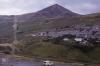
Llun: 1
Tylorstown Tip, Rhondda Fach. View from tops
Tylorstown tip and tramway from Wattstown, 1971
Dyddiad: 1971
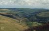
Llun: 2
Tylorstown Tip, Rhondda Fach. View from tops
Wattstown tip above Wattstown just South of Tylorstown. Ynyshir and Porth at junction of 2 Rhondda rivers
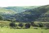
Llun: 3
Tylorstown Tip, Rhondda Fach. View from tops
View down Rhondda Fach to confluence with R. Fawr at Porth. Top right towards Tonyrefail is Rhiwgarn. Wattstown (left) Mid is Ynishir (Ynis is island, hir is something to do with water (?) between rivers
Ffynhonnell allanol:

More items with these tags


Cysylltwch â Ni
I wneud cais i dynnu i lawr neu riportio cynnwys hiliol, sarhaus neu niweidiol mewn unrhyw ffordd arall.

Sylwadau (1)
Submitted by Angela Hughes on Llun, 18/03/2024 - 11:20
I would suggest the houses are part of Stanleytown and the photograph taken from the site of Tylorstown colliery with the route up to Tylorstown tip.
You must be logged in to leave a comment